

See How We Bring GIS Ideas to Life
-
Location:
Germany
Automatic Tree Recognition with ArcGIS Pro is a project that aims to develop and implement an algorithm for automatic recognition of tree species based on remote sensing data.

-
Location:
Canada
The project encompasses the digitization of utility service connections, specifically for water, sewer, and storm services, spanning across 12,706 properties (parcels) within the City.


-
Location:
Poland
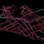
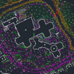
The databases are created and updated by vectorizing existing raster data (topographic maps), orthophotomaps and processing geodetic files and land documentation (by coordinates and sketches).

-
Location:
Poland
Editing the automatically generated database of motorways, bridges and roads.

-
Location:
Latvia
Precision 2D Vector Map Creating at 1500 Scale

-
Location:
Ukraine
Our GIS specialists performed a complete data conversion, meeting all the client’s requirements and ensuring high quality of information processing.


-
Topological Verification and Correction of Seafloor Maps


-
Location:
Poland
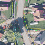
Using an orthophotomap, we check the relevance of the existing topographic objects in the database, as well as create new ones (which are not in the existing database).

-
Location:
Poland
The project involved validating the current entries in the database for accuracy and completeness, identifying and adding new buildings that were absent from the existing database, and rectifying any geometric discrepancies in building representations. -
We check the relevance of existing buildings in the database, as well as create new ones (which are not in the existing database), using orthophoto, Street View, topographic maps and other supporting materials.


-
Location:
Czech Republic, Prostejov
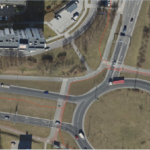
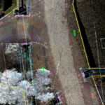
To create a 2D vector map in the city of Prostejov that includes road infrastructure and road signs.


-
Location:
Poland
GIS Construction of 2D orthomosaic for aerial photography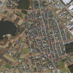
-
Project on vectorization of objects obtained from mobile map data


-
Location:
Poland
Classification and build a DEM, DSM, DMT, TIN

-
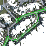
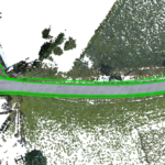
This map encompasses road networks and their immediate surroundings, extending 15 meters from the road centerlines. It features comprehensive attribute information for each object, including object types, surface materials, and height above ground level.


-
Location:
Norway
Within the scope of this task, data from a portion of Oslo city was processed, specifically LAS/LAZ files and vector data for buildings, utility poles, and power transmission lines (with a focus on this vector area).

-
Location:
Norway
We received data of a part of Oslo city, namely LAS/LAZ files and a vector of buildings, poles and power lines (these classes had to be processed within the vector).


-
Comprehensive Urban Infrastructure 2D Mapping and Attribute Database Development


-
Location:
Czech Republic
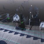
To create a digital 3D map from mobile lidar scanning data and panoramic imagery.


-
Location:
Czech Republic
The input data is a cloud of Lidar points obtained using mobile Lidar scanning, as well as orthophoto maps, 360 panoramic photos. -
Location:
Czech Republic
A digital spatial 3D model of a concrete support was created in Bentley MicroStation – Terra solid based on laser scanning.


-
Creation and updating of topographics data and underground communications databases on a scale of 1:500.


-
Location:
Czech Republic
To create 3D models of the tunnel and 2D sections based on Laser Scanning.


-
Location:
Poland
Classification of point clouds for obtaining high-quality digital DEM, DSM, DTM, TIN models and determination of areas with snow cover.
-
Utilizing data from mobile LiDAR scanning, panoramic imagery, and digital elevation maps, our project focuses on the development of an intricate 3D-map.

-
Digital 3D Mapping from Mobile LiDAR and Panoramic Imagery
-
This project focuses on generating a Digital Terrain Model (DTM) using LiDAR data.


-
Modern software solutions enable accurate forest inventory by harnessing LiDAR laser scanning data.


-
Location:
Ukraine
Accurate and detailed DTM representing the terrain features of the surveyed area.

-
Location:
Lviv, Ukraine
3D laser scanning and creating BIM-model of an object.


-
Location:
Lviv, Ukraine
3D laser scanning of the object, namely the T1416 overpass over the railway track, and the creation of its BIM-model

-
Location:
Kryvyi Rih, Ukraine
3D laser scanning and creating BIM-model of several buildings, which are monuments of architecture and urban planning of local significance in Kryvyi Rih, with accurate design of all decorative elements: stucco, balconies, windows, parapets, etc.


-
Location:
Latvia
To create a 2D vector map based on ortho photo plan and laser scanning according to Latvian legislation at a scale of 1:500. -
Location:
France
Acquiring a point cloud with a detailed classification of power lines, including the determination of the phases for each wire, and a thorough classification of the DSM terrain within a 60-meter corridor.

-
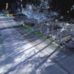
Our team has successfully completed this 3D road network inventory project, which included detailed digitization of various street objects.
-
Location:
Netherlands
Topographic map in 3D from Mobile LiDAR and Panoramic Imagery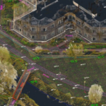
-
Location:
Czech Republic
The aim of the project was to bring the vector maps in line with the current state of the terrain. For this purpose, the vector was audited for the presence and correctness of objects localisation based on aerial photography.

-
The project focused on capturing streets, track axles, anomalies, drainage systems, sidewalks, signage, and more.
-
Location:
Poland
Acquiring a point cloud with specific target classes: road, sidewalk, buildings, ground, vegetation, road signs, street infrastructure, and street furniture.

-
A portal for the sale of satellite images


-
Development of an Interactive Street Panorama and GIS Layer Management Platform


-
Development software for a soil subsidence


-
Software solution to manage all transportation processes and activities across logistics networks.

-
Software Development for the energy industry to control and track of logistics, drilling, mining.

-
Software development for a weather forecast program


-
Develop software for public transport which display on tables arrival information about bus, tram and trolleybus.

-
The system is designed to comprehensively address the issues of public passenger transport

Our clients say
Our Team

Ievgen Lavrishko
CEO & Owner

Khrystyna Bochko
HR Generalist

Alevtyna Kostianchuk
Senior Project Manager

Andriiana Pavlyshyn
Head of Business Development

Roman Nahaiovskyi
Project Manager

Maria Kizim
Lead Generation Specialist

Ivanna Soltys
Tender Manager