DatenproduktionGIS & Geospatial
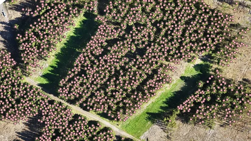
Automatische Baumerkennung aus Orthophotos
Wir bauten ein System, das die Waldinventur automatisiert. Mit Geoinformationstechnik und maschinellem Lernen bestimmt es die Lage von Bäumen genau und schnell über große Flächen.
Projektüberblick
Deutsche Bundesforstverwaltung
- Location
- Deutschland
- Team
- GisPoint übernahm: Die Projektleitung plante, koordinierte und kontrollierte das Projekt. GIS-Fachleute erhoben die Daten, entwickelten die Algorithmen und testeten und implementierten die Modelle für maschinelles Lernen in ArcGIS Pro. Die Qualitätskontrolle bewertete die Genauigkeit der Ergebnisse gegen die Qualitätsvorgaben.
Stack
- Survey & CAD
- The project runs on ArcGIS Pro with deep learning tools, which is what gets tree locations found automatically at the accuracy required. The output is a detailed map of forest areas for forest management.
Die Aufgabe und was sie gelöst hat
Technical challenge
Baumstandorte mit ArcGIS Pro automatisch zu finden ist nicht einfach. Worauf wir gestoßen sind: Rauschen und Artefakte: Schatten, Wolken, atmosphärische Effekte und Sensorrauschen stören die Segmentierungsalgorithmen. Spektrale Eigenschaften: Baumarten unterscheiden sich, ebenso ihr Zustand (gesund, krank, jung, alt) und das Wetter, was die spektrale Signatur so weit verschiebt, dass die Klassifizierung schwierig wird. Rechenressourcen: Datenmengen und Modelle des maschinellen Lernens verlangten entsprechende Hardware. Aufbau der Trainingsdaten: Einen Trainingsdatensatz mit genauen Annotationen aufzubauen war aufwendig. Solche Punkte gehören zu Projekten dieser Art, und jeder musste abgearbeitet werden.
Was wir gemacht haben
Automatische Baumerkennung aus Orthophotos. Einsatz von Algorithmen des maschinellen Lernens für die Datenauswertung. Einbindung der Algorithmen in GIS-Anwendungen.
Warum wir
Das Projekt lief in ArcGIS Pro, das sowohl die Daten als auch die Rechenlast trug. Die Phasen: Entwicklung des Klassifizierungsalgorithmus: Mit ArcGIS Pro und seinen Werkzeugen für maschinelles Lernen entstand ein Algorithmus, der Bildpixel klassifiziert und jeden Baum verortet. Test und Validierung des Modells: Die Genauigkeit des Modells wurde an einer unabhängigen Stichprobe gegen manuelle Zählung und postalische Erhebungen geprüft. Kartenerstellung: Aus den Klassifizierungsergebnissen entstanden digitale Karten mit der Lage jedes Baums.
Ergebnisse
Das Projekt erreichte eine hohe Genauigkeit der Baumkoordinaten (90 %), was detaillierte Angaben zu ihrer Lage im Wald ermöglicht. Eine erhebliche Datenmenge (600 Hektar) wurde verarbeitet, und es entstanden detaillierte Karten der Baumverteilung.
Was wir geliefert haben
Automatische Baumerkennung aus Orthophotos.
Einsatz von Algorithmen des maschinellen Lernens für die Datenauswertung.
Einbindung der Algorithmen in GIS-Anwendungen.