Data ProductionGIS & Geospatial
3D and 2D Models of a 25 m Tunnel
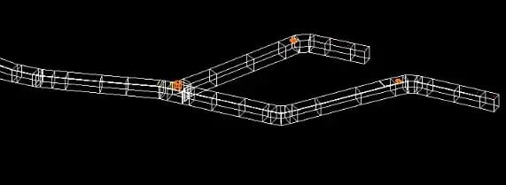
The project involved the creation of a digital spatial 3D model of a 25-meter tunnel, along with 2D cross-sections and longitudinal sections.
Project snapshot
A geodetic and engineering company specializing in surveying, property management, and geospatial solutions.
- Location
- Czech Republic
- Team
- A GisPoint team working in LIDAR data processing and modelling delivered the project, producing a digital model precise enough for structural analysis and future maintenance work.
Stack
- Survey & CAD
- Bentley MicroStation: Used for 3D modeling and generating 2D cross-sections Terra solid: Employed for LIDAR data processing and model refinement
The challenge, and what closed it
Technical challenge
Capturing the exact structure and geometry of the tunnel in the 3D model. Producing cross-sections that match the real dimensions of the tunnel. Working through large volumes of LIDAR data inside the project timeline.
What we did
A digital 3D model of a tunnel built from laser scanning data. 2D cross-sections and longitudinal sections of the tunnel. High-precision modelling for use in design, construction, repair, and inspection. Tunnel geometry represented accurately enough for structural analysis.
Why us
Data Acquisition: laser scanning data was collected to capture the tunnel’s geometry. 3D Model Creation: the 3D model of the tunnel was built in Bentley MicroStation - Terra solid. 2D Section Creation: cross-sections and longitudinal sections were produced for the structural overview. Accuracy Checks: the models were reviewed for precision and for use in infrastructure applications.
Results
A 3D model of the tunnel was delivered along with 2D cross-sections and longitudinal sections. It shows the tunnel’s structure in detail and supports project planning, construction, and maintenance work.
What we delivered
Creation of a digital 3D model of a tunnel based on laser scanning data
Generation of detailed 2D cross-sections and longitudinal sections of the tunnel
High-precision modelling for use in design, construction, repair, and inspection
Accurate representation of tunnel geometry for detailed structural analysis