Software EngineeringAgriculture & AgriTech
AgriZone: Management Zones from Satellite Imagery in Minutes
Client: GIS-Point (white-label product)
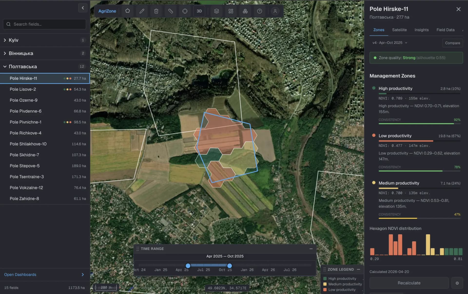
AgriZone is GIS-Point's white-label platform for agronomists. They pick a field and get productivity zones calculated from two seasons of Sentinel-2 imagery. A companion mobile app shows field teams which zone they are standing in, including offline.
Project snapshot
AgriZone is a white-label product built and owned by GIS-Point. Its requirements came from a tender by a large Ukrainian agroholding that farms hundreds of thousands of hectares. The product is built for agribusinesses of that size, which need zoning across a whole land bank rather than one field at a time.
- Location
- Ukraine
- Duration
- 3 months to first release
- Team
- 1 frontend + 1 backend + 1 mobile engineer + 1 QA
Stack
- Frontend
- Next.js, React, TypeScript, Tailwind CSS, OpenLayers, deck.gl, Recharts; mobile: React Native, MapLibre Native, SQLite
- Backend
- Python, FastAPI, SQLAlchemy, Celery, Redis
- Data & AI
- Sentinel Hub (Copernicus Sentinel-2), Copernicus DEM, H3, scikit-learn, rasterio, PostgreSQL + PostGIS, GeoServer
- Infrastructure
- Docker Compose, Caddy, Hetzner Cloud, Sentry
The challenge, and what closed it
Business challenge
Large agroholdings vary seed and fertiliser rates by management zone, but zones were drawn by hand in desktop GIS. That takes a specialist, so only part of the land bank ever got zoned, and the rest was farmed at flat rates. The business needed zoning to be a routine step every agronomist can run, not a GIS project.
What we did
Zoning became a one-click action. An agronomist opens the map, draws or picks a field, sets how many zones they want, and gets ranked high, medium and low productivity zones in minutes. Zones can be recalculated, compared across versions and exported to the tools the farm already uses. Covering the whole land bank is now a matter of clicking through fields, not of specialist hours.
Technical challenge
Satellite data over farmland is messy. Clouds and haze hide whole summer scenes, field boundaries are irregular, and one good image is not enough to tell a persistently weak area from a bad week. Agronomists also needed zones they could trust and explain, not a black-box map. And the result had to reach people standing in a field, often with weak or no mobile signal.
What we did
For each field, AgriZone pulls the clearest Sentinel-2 images across two growing seasons. It masks clouds and combines vegetation (NDVI) and soil-brightness (SBI) signals with terrain. It then divides the field into a uniform hexagon grid, groups similar hexagons into zones, and ranks those zones by productivity. Every calculation comes with a quality score and supporting charts, so an agronomist can see how clean the zoning is before acting on it.
Delivery challenge
The tender covered a full web platform, a field mobile app, role-based access for many farm units, and two interface languages, and the first release had to be ready in a few months. The team was small: four people covering web, backend, mobile and QA.
What we did
The team shipped in focused milestones, starting with the core field-to-zones flow and then adding history, exports, dashboards, multi-organisation access and the mobile app. The first release was ready in three months. Planning, automated tests on backend and mobile, and end-to-end mobile flows kept four people shipping in parallel without regressions.
Why us
GIS-Point already delivers production remote-sensing and GIS work, including Sentinel-2 processing, soil mapping and precision-agriculture monitoring platforms. That meant the team started from a working knowledge of the imagery and the agronomy, not from scratch. One team could also deliver the processing pipeline, the web GIS and the native mobile app together, so there were no hand-offs between vendors.
- Month 1
Core zoning pipeline
Field drawing, Sentinel-2 ingestion with cloud filtering, hexagon grid and zone calculation, end to end on the map.
- Month 2
Platform features
Calculation history, versions and comparison, exports, dashboards, English and Ukrainian interface.
- Month 3
Access control and mobile
Multi-organisation roles and permissions, security hardening, and the offline-capable field mobile app.
What we delivered
One-click management zones
Draw or select a field, choose the number of zones, and get productivity-ranked zones from two seasons of cloud-filtered Sentinel-2 imagery.
Zone quality and explainability
Each calculation shows a cluster-quality score, index statistics per zone and dashboards, so agronomists can judge the result before using it.
History, versions and comparison
Re-run calculations, keep versions of a field's zoning and compare them side by side.
Exports and imports
Export zones with application rates as GeoJSON or Shapefile, and import applied maps from ISOXML or GeoJSON.
Multi-organisation access control
Separate organisations and farm units with role-based permissions, MFA and an audit log for platform administrators.
Field mobile app
A native Android/iOS app shows zones on the map, uses GPS to tell a worker which zone they are standing in, and keeps working offline with cached maps.
Project gallery
Facing something similar?
We build satellite-driven agronomy tools, as white-label products or custom to your land bank.