

Choose GIS-Point – Where UX Meets Spatial Intelligence
At GIS-Point, we specialize in delivering UX/UI design services that bridge the gap between complex geospatial data and user-friendly digital experiences. With over six years of experience in GIS and software development, our team understands the intricacies of spatial data and how to present it effectively to end-users.
What Is UX/UI Design Services?
At GIS-Point, we deliver UX/UI design services that simplify complexity and put the user first — especially when working with spatial data and enterprise applications. Our team conducts user research, builds prototypes, defines clear information architecture, and delivers engaging visual design. Every project is built with a deep understanding of user workflows and geospatial logic, ensuring the interface works as beautifully as it looks.
We serve industries like transportation, logistics, energy, agriculture, and real estate, where intuitive interaction with data is critical. Whether designing dashboards, mobile apps, or complex GIS systems, we create scalable solutions that support product goals, improve usability, and enhance engagement across devices and platforms.

Our UX/UI Design Services

- User Research & Analysis: Conducting thorough research to understand user needs and behaviors.
- Information Architecture: Structuring content and functionality to align with user expectations.
- Wireframing & Prototyping: Developing interactive prototypes to visualize and test design concepts.
- Visual Design: Creating aesthetically pleasing designs that reflect your brand identity.
- Usability Testing: Evaluating designs with real users to identify areas for improvement.
- Design Systems Development: Establishing a cohesive set of design standards for consistency across platforms.
Partner with GIS-Point to transform your digital products into intuitive and engaging experiences.
Our expertise in UX/UI design and geospatial technologies ensures that your applications not only look great but also deliver exceptional functionality.
Industries we serve

Transportation

Logistics

Energy

Agriculture

Automotive

Delivery

Real Estate

Retail & E-Commerce:
Working on the Project:
A Step-by-Step Journey to Success

-
Discovery
Understanding your business goals, user needs, and technical requirements.
-
Strategy
Developing a design strategy that aligns with your objectives.
-
Design
Creating wireframes, prototypes, and visual designs.
-
Testing
Conducting usability tests to gather feedback and refine designs.
-
Implementation
Collaborating with development teams to bring designs to life.
-
Optimization
Monitoring user interactions post-launch to make data-driven enhancements.
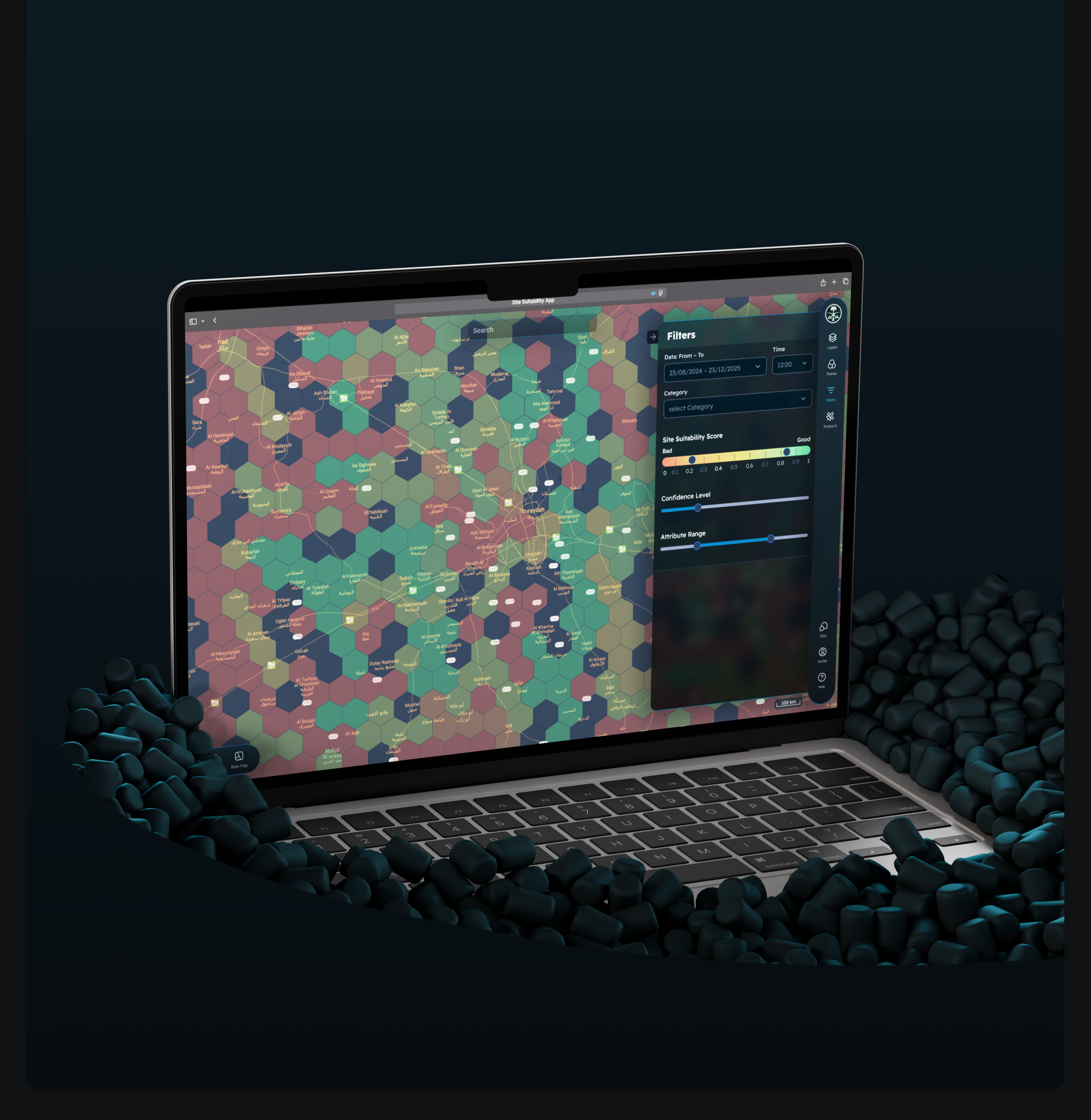
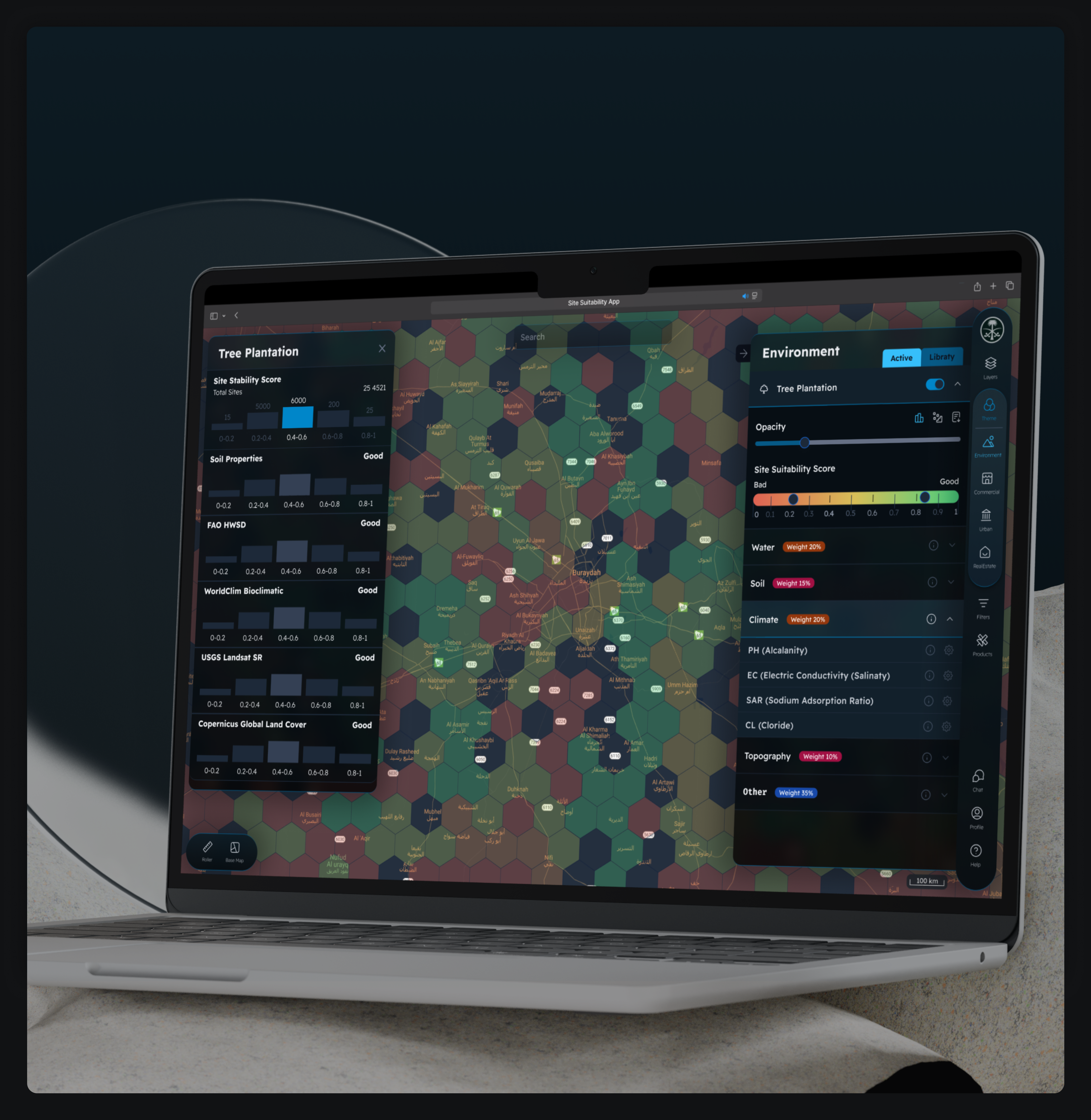
Discover the Interfaces and Experiences We’ve Designed
-
This map encompasses road networks and their immediate surroundings, extending 15 meters from the road centerlines. It features comprehensive attribute information for each object, including object types, surface materials, and height above ground level.


-
Comprehensive Urban Infrastructure 2D Mapping and Attribute Database Development


-
Location:
Norway
Within the scope of this task, data from a portion of Oslo city was processed, specifically LAS/LAZ files and vector data for buildings, utility poles, and power transmission lines (with a focus on this vector area).

-
Topological Verification and Correction of Seafloor Maps


-
Location:
Poland
Editing the automatically generated database of motorways, bridges and roads.

-
Location:
Latvia
Precision 2D Vector Map Creating at 1500 Scale

-
A portal for the sale of satellite images


-
Development of an Interactive Street Panorama and GIS Layer Management Platform


-
Software development for a weather forecast program


-
Development of a Precision Agriculture Site Monitoring Platform


-
Development of a Web-Based 3D Point Cloud Visualization Platform


-
Development Web Platform for Digital Soil Mapping and Analysis
Ready to elevate your product experience?
Let’s design smart, intuitive interfaces your users will love.

Customers have no doubt about our expertise
Our team ofprofessionals

Ievgen Lavrishko

Khrystyna Bochko

Alevtyna Kostianchuk

Andriiana Pavlyshyn

Roman Nahaiovskyi

Maria Kizim

Ivanna Soltys
Why Choose GIS-Point for UX/UI Design?
Deep Industry Expertise
User-Centered Design Approach
Integration with Geospatial Data
Scalable and Flexible Solutions
Contact us today to discuss how we can support your UX/UI design needs.
United Kingdom
Devonshire str., 41, Ground Floor, London W1G 7AJ, UK
Estonia
Harju maakond, Tallinn, Kesklinna linnaosa, Kaupmehe tn 7-120, 10114, Estonia