

Choose GIS-Point – Your Long-Term Tech Partner for Startup Growth
At GIS-Point, we specialize in supporting startups and scale-ups through every stage of their journey—from initial concept to market-ready product. With over 6 years of experience, our team offers comprehensive services tailored to the unique needs of emerging businesses.
What are Startup Technology Partner Services by GIS-Point?
GIS-Point offers end-to-end technology support for startups at every stage — from idea validation to full-scale product development. We help you rapidly prototype and launch MVPs, design user-friendly interfaces, and build robust custom software tailored to your niche. Whether you’re in logistics, agriculture, energy, or real estate, our expertise in GIS and IT ensures a powerful, data-driven foundation for your product.
Our managed teams provide flexibility, speed, and domain knowledge to help you scale efficiently without overhead. We act as your integrated tech partner — streamlining operations, supporting infrastructure, and adapting to your evolving business goals. With GIS-Point, your startup gets more than code — it gets a committed partner in innovation.

Our Services

- MVP Development
Rapid development of functional products with core features to test your business idea in the market.
- UX/UI Design
Creating intuitive and engaging user interfaces that align with your brand and enhance user experience.
- Custom Software Development
Tailored GIS and IT solutions to enhance your geospatial capabilities and business processes.
- IT Infrastructure & System Management
Optimizing and maintaining your IT systems for seamless operation and scalability.
- Dedicated GIS and IT Teams
Providing dedicated teams to help businesses integrate geospatial solutions, GIS data processing, and software development into their operations.
Let’s Build the Future Together
Partner with GIS-Point to transform your innovative ideas into successful digital products. Our comprehensive services, industry expertise, and dedicated teams are here to support your startup’s growth every step of the way.
Industries we serve

Transportation & Road Safety

Logistics & Supply Chain

Energy & Utilities

Agriculture

Automotive & Mobility

Delivery & Last-Mile Solutions

Retail & E-Commerce

Real Estate & Urban Planning

Healthcare & Life Sciences

Finance & Insurance

Public Infrastructure
Our Process

-
Discovery & Research
Understanding your business goals, user needs, and market landscape.
-
Strategy & Planning
Defining the design approach, creating user personas, and mapping user journeys.
-
Design & Prototyping
Developing wireframes, visual designs, and interactive prototypes.
-
Testing & Validation
Conducting usability tests to gather feedback and refine designs.
-
Implementation Support
Collaborating with development teams to ensure seamless integration of designs.
-
Post-Launch Optimization
Monitoring performance and making iterative improvements based on user data.
Discover Our Delivered MVPs and Startup Tech Solutions
-
This map encompasses road networks and their immediate surroundings, extending 15 meters from the road centerlines. It features comprehensive attribute information for each object, including object types, surface materials, and height above ground level.


-
Comprehensive Urban Infrastructure 2D Mapping and Attribute Database Development


-
Location:
Norway
Within the scope of this task, data from a portion of Oslo city was processed, specifically LAS/LAZ files and vector data for buildings, utility poles, and power transmission lines (with a focus on this vector area).

-
Topological Verification and Correction of Seafloor Maps


-
Location:
Poland
Editing the automatically generated database of motorways, bridges and roads.

-
Location:
Latvia
Precision 2D Vector Map Creating at 1500 Scale

-
A portal for the sale of satellite images


-
Development of an Interactive Street Panorama and GIS Layer Management Platform


-
Software development for a weather forecast program


-
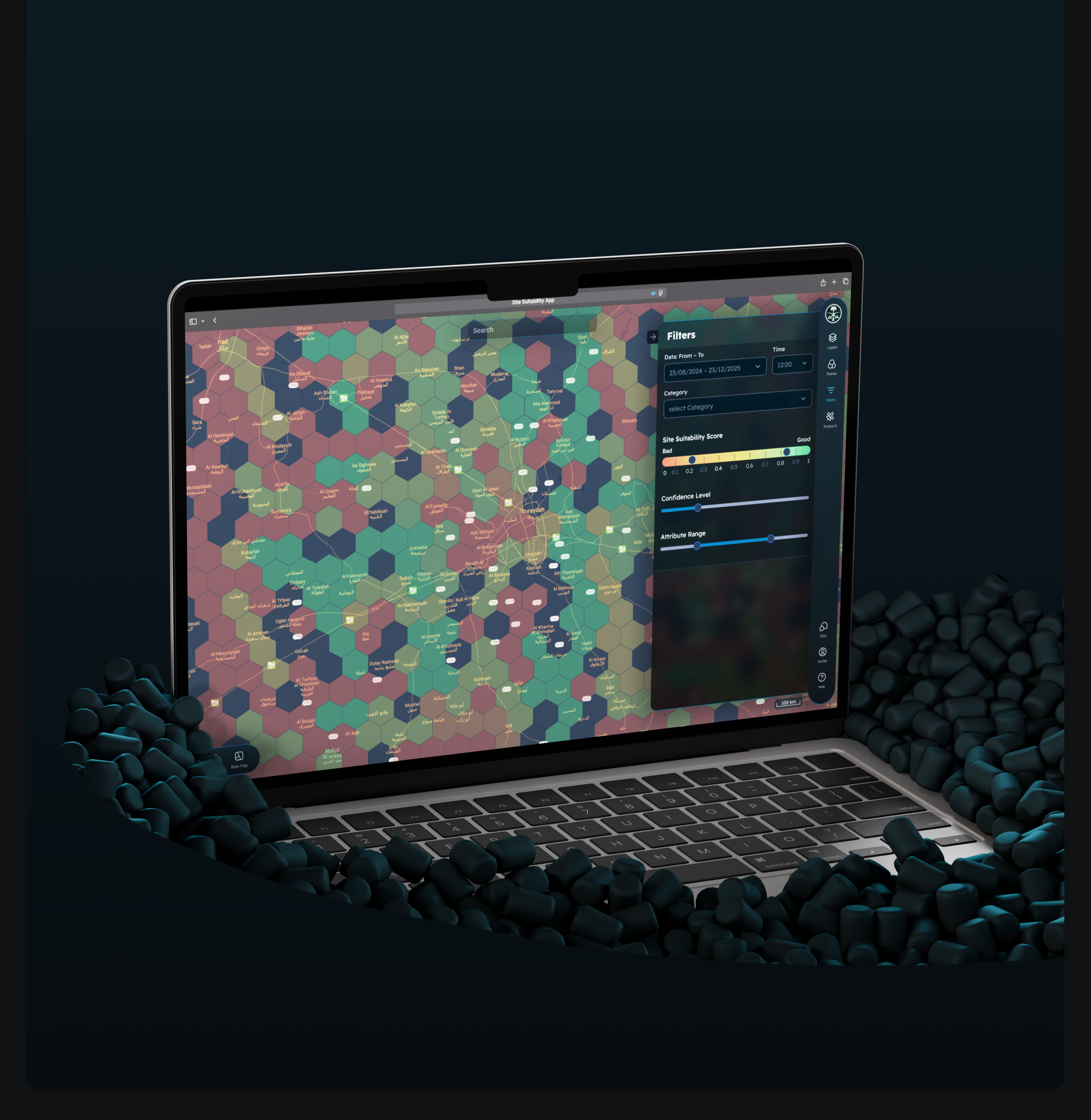
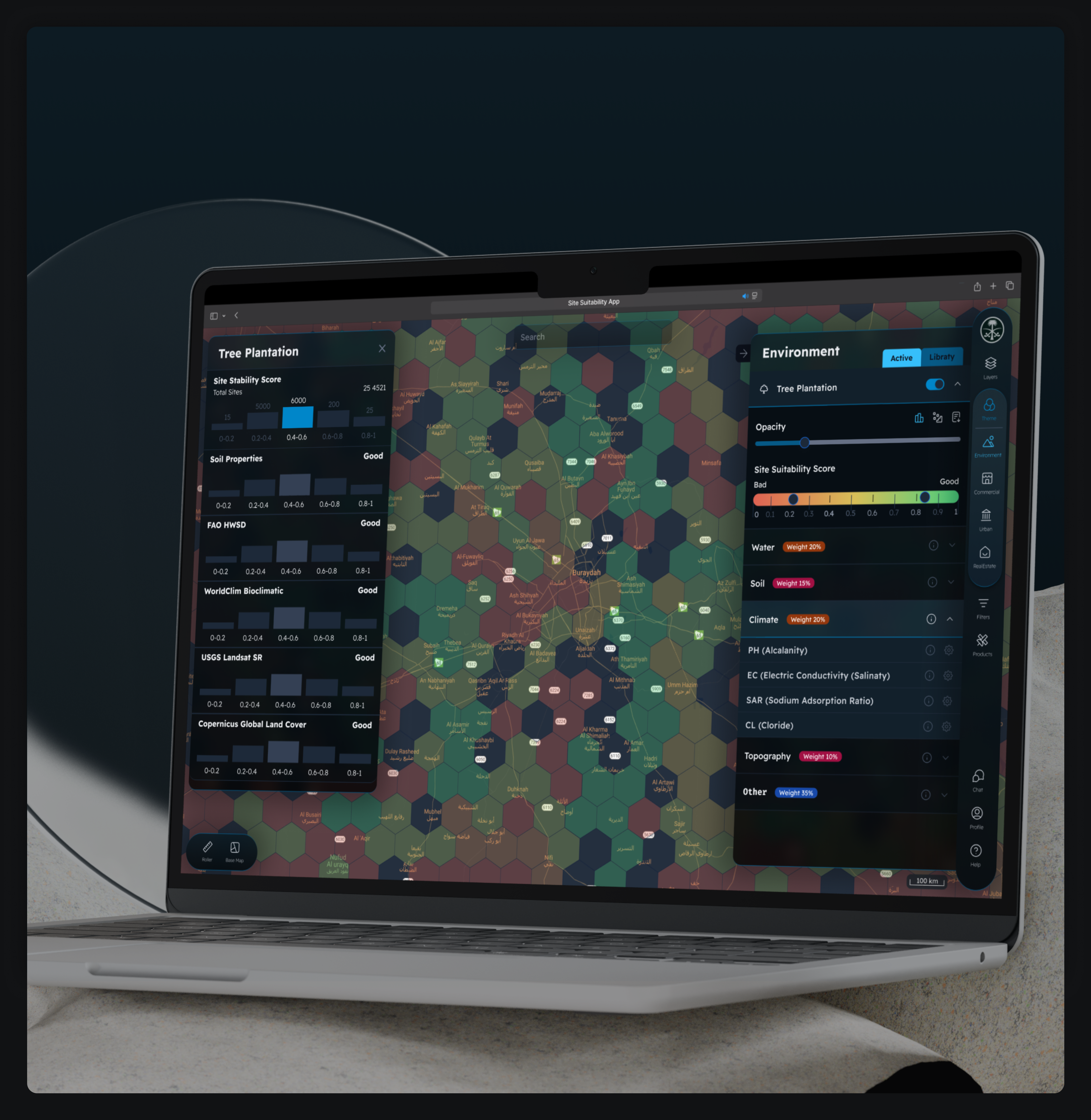
Development of a Precision Agriculture Site Monitoring Platform


-
Development of a Web-Based 3D Point Cloud Visualization Platform


-
Development Web Platform for Digital Soil Mapping and Analysis
Have a bold idea and need a reliable tech partner to build it?
Partner with GIS-Point and take your startup to the next level with expert guidance and scalable development.

Customers have no doubt about our expertise
Our team ofprofessionals

Ievgen Lavrishko

Khrystyna Bochko

Alevtyna Kostianchuk

Andriiana Pavlyshyn

Roman Nahaiovskyi

Maria Kizim

Ivanna Soltys
Why Choose GIS-Point?

- Comprehensive Support Across All Stages
- Idea Validation & Prototyping: We help transform your innovative ideas into tangible prototypes, enabling early feedback and validation.
- MVP Development: Our team rapidly develops Minimum Viable Products to test market fit and gather user insights.
- Full-Scale Product Development: We provide end-to-end development services, scaling your MVP into a robust, market-ready product.
- Dedicated Teams with Domain Expertise
Our professionals bring deep knowledge in both GIS and IT, ensuring a comprehensive approach to solving your challenges. We adapt to your project’s needs, providing both short-term and long-term support. Our teams integrate directly with your business, ensuring smooth and effective communication.
- Cost-Effective Solutions
Our flexible service models help you optimize costs while maintaining the highest quality of service.
Contact us today to discuss how we can help bring your vision to life.
United Kingdom
Devonshire str., 41, Ground Floor, London W1G 7AJ, UK
Estonia
Harju maakond, Tallinn, Kesklinna linnaosa, Kaupmehe tn 7-120, 10114, Estonia