

Proven Expertise in Turning Complex Geospatial Data into Business Value
From Data Overload to Spatial Intelligence

Pain Points & Solution Narrative
❌ Fragmented Geospatial Workflows
Multiple data sources (satellite, aerial, IoT) often require manual preprocessing and synchronization — wasting time and resources.
✅ Unified AI-Powered Geospatial Pipeline
GeoAI automates image analysis, feature detection, and spatial modeling — turning complex data streams into consistent, structured insights.
❌ Slow, Manual Interpretation
Traditional GIS analytics rely heavily on human interpretation, causing delays and inconsistent accuracy across teams.
✅ Faster Decision-Making Through Automation
AI-driven spatial analytics deliver real-time monitoring and anomaly detection — enabling response in minutes, not weeks.
❌ Limited Predictive Capability
Without AI-driven models, forecasting land use, risk, or environmental change is guesswork rather than science.
✅ Predictive and Scalable Insights
Machine learning models forecast change, identify patterns, and scale across industries — from agriculture to urban infrastructure.
Discover how GeoAI transforms your geospatial operations
No commitment — talk with our GeoAI expert about your spatial analytics goals.
Proven Experience. Measurable Impact.
With 390+ international projects and 6+ years of LiDAR and GIS expertise, we bring precision and reliability to every geospatial challenge.
Benefits of GIS for Agriculture and Farming
| Sector | Use Case | Quantified Impact |
|---|---|---|
| Agriculture | Precision farming using GeoAI for soil, crop and moisture analysis | +10–15% yield increase; -20% fertilizer use; -30% irrigation water |
| Urban Planning / Smart Cities | Traffic & land-use optimization through AI-enhanced GIS | -20–30% traffic congestion; +25% improvement in public transport efficiency |
| Logistics & Supply Chain | Route optimization via adaptive GeoAI and IoT integration | -15–25% logistics costs; -20% delivery time |
| Environmental Monitoring | Remote sensing + AI for pollution detection and disaster prediction | Up to 99% detection accuracy; +80% faster emergency response |
| Resource Management | GeoAI for sustainable land, water and forest use | -15–30% resource waste reduction; +20% sustainability index |
| Disaster Risk Management | AI-driven flood prediction and mitigation planning | +90% accuracy in high-risk zone identification |
Scientific Publications
Ahmed, Z., 2024 – Artificial Intelligence Geographic Information Systems (AI GIS). International Journal of Advanced Engineering and Business Sciences.
Chukwuma, U., Gebremedhin, K., & Uyeh, D., 2024 – Imagining AI-driven Decision Making for Managing Farming in Developing and Emerging Economies. Computers and Electronics in Agriculture, 221.
Dritsas, E., & Trigka, M., 2025 – Remote Sensing and Geospatial Analysis in the Big Data Era: A Survey. Remote Sensing.
Fauzi, C., 2024 – A Review of Geospatial Artificial Intelligence (GeoAI): Implementation of Machine Learning on Urban Planning. Jurnal Multidisiplin Indonesia.
Gangwani, N., 2024 – AI-Driven Precision Agriculture: Optimizing Crop Yield and Resource Efficiency. International Journal for Multidisciplinary Research.
Gupta & Bhatnagar, 2025 – Harnessing AI in Geospatial Technology for Environmental Monitoring and Management. IGI Global.
Jones, A., Kuehnert, J., Fraccaro, P., Meuriot, O., Ishikawa, T., Edwards, B., Stoyanov, N., Remy, S., Weldemariam, K., & Assefa, S., 2023 – AI for Climate Impacts: Applications in Flood Risk. npj Climate and Atmospheric Science, 6.
Jones, J., Harris, E., Febriansah, Y., Adiwijaya, A., & Hikam, I., 2024 – AI for Sustainable Development: Applications in Natural Resource Management, Agriculture, and Waste Management. International Transactions on Artificial Intelligence (ITALIC).
Liang, L., Daniels, J., Bailey, C., Hu, L., Phillips, R., & South, J., 2023 – Integrating Low-cost Sensor Monitoring, Satellite Mapping, and Geospatial Artificial Intelligence for Intra-urban Air Pollution Predictions. Environmental Pollution.
Maraveas, C., 2022 – Incorporating Artificial Intelligence Technology in Smart Greenhouses: Current State of the Art. Applied Sciences.
Marasinghe, R., Yigitcanlar, T., Mayere, S., Washington, T., & Limb, M., 2024 – Towards Responsible Urban Geospatial AI: Insights from the White and Grey Literatures. Journal of Geovisualization and Spatial Analysis.
Padhiary et al., 2025 – Precision Agriculture and AI-driven Resource Optimization for Sustainable Land and Resource Management. IGI Global.
Prabhanjana et al., 2025 – Optimizing Flood Risk Management through Geospatial AI and Remote Sensing. IGI Global.
Rezvani et al., 2024 – Mapping Geospatial AI Flood Risk in National Road Networks. International Journal of Geo-Information (MDPI).
Thuraka, 2021 – AI-Driven Adaptive Route Optimization for Sustainable Urban Logistics and Supply Chain Management. ResearchGate.
Zahra et al., 2023 – Application of Geospatial Techniques in Agricultural Resource Management. IntechOpen.
Get a Free Technical Consultation
Discuss your data challenges with our GeoAI expert — no obligation, no sales pitch.
Everything You Want to Know About GeoAI Integration and Results

-
What data do we need to provide for GeoAI analysis?
GeoAI solutions can process both your proprietary data and publicly available sources such as Sentinel, Landsat, or drone imagery. Depending on your project, we can use raster data (satellite, LiDAR, multispectral), vector datasets, or sensor streams (IoT). If you don’t have your own datasets, we can access licensed or open repositories to ensure high-quality spatial coverage.
-
How accurate are the GeoAI models and predictions?
GeoAI models usually outperform traditional GIS methods in precision and generalization.
Recent studies report up to 97% accuracy in building detection, land-use classification, and soil prediction tasks.
Accuracy varies depending on data quality, model architecture, and geographic complexity, but uncertainty can be quantified using conformal prediction frameworks.
-
Can GeoAI integrate with our existing GIS or enterprise systems (ArcGIS, QGIS, SAP, etc.)?
Yes. GeoAI platforms are designed for seamless integration with enterprise GIS and data infrastructures.
Our models and APIs are fully compatible with ArcGIS, QGIS, PostGIS, AWS, Azure, and SAP environments, allowing automated data exchange through RESTful APIs or direct plugin connections.
-
Can GeoAI solutions work offline or on private infrastructure (edge, on-prem)?
Yes. For government, defense, or critical infrastructure clients, we support on-premise and edge deployments.
Models can be containerized via Docker or Kubernetes, ensuring full control over data privacy and processing inside your secured environment, without dependence on cloud connectivity.
-
What industries benefit most from GeoAI applications?
GeoAI drives measurable efficiency across multiple sectors:
- Agriculture — up to +15 % yield and −20 % fertilizer usage;
- Urban & Mobility — −30 % traffic congestion and faster infrastructure planning;
- Logistics — −25 % routing costs;
- Environmental Monitoring — +80 % faster event detection [Gupta et al., 2025].
These data-driven insights confirm GeoAI’s impact on sustainability, resource optimization, and decision-making speed.
Integrate GeoAI into Your Data Stack Seamlessly
United Kingdom
Devonshire str., 41, Ground Floor, London W1G 7AJ, UK
Germany
Estonia
Harju maakond, Tallinn, Kesklinna linnaosa, Kaupmehe tn 7-120, 10114, Estonia
Ukraine
Lviv, Sadova street, 2a/1
What Are Geospatial AI Services
Geospatial AI (GeoAI) combines Geographic Information Systems (GIS), remote sensing, and artificial intelligence to extract actionable insights from spatial data.
By applying machine learning, computer vision, and deep neural networks to satellite imagery, LiDAR scans, and IoT sensor data, GeoAI automates tasks such as mapping, land-use classification, object detection, and predictive modeling.
This integration of data → models → insights → decisions enables organizations to monitor changes, optimize operations, and make data-driven spatial decisions in real time — across agriculture, urban planning, logistics, and environmental management.
Key Service Capabilities
Our GeoAI Services combine advanced geospatial analytics, AI modeling, and cloud automation to deliver precise, real-time spatial intelligence. Each capability is designed to turn raw geodata into measurable business value — from satellite image processing to predictive forecasting and intelligent geospatial assistants.
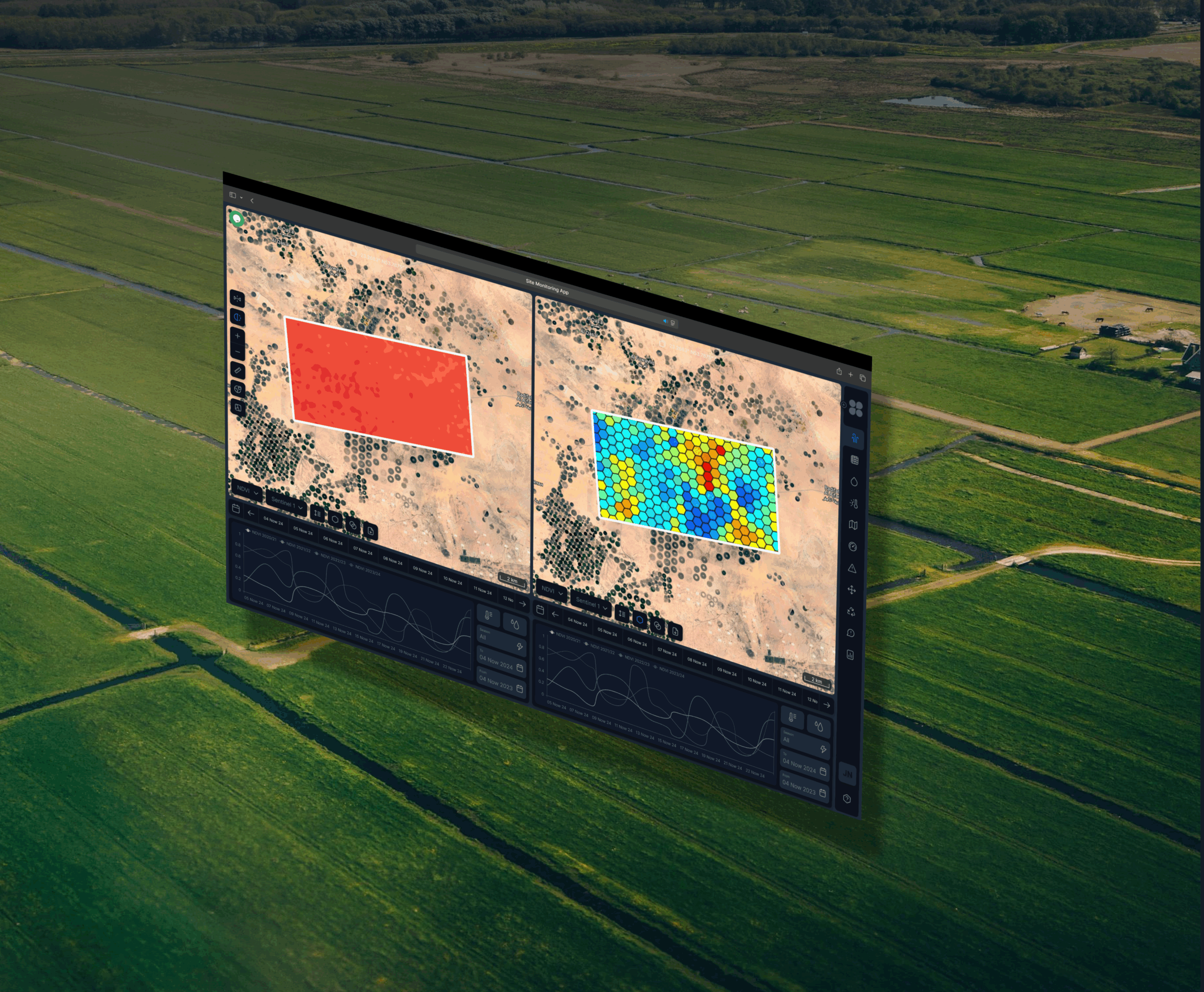
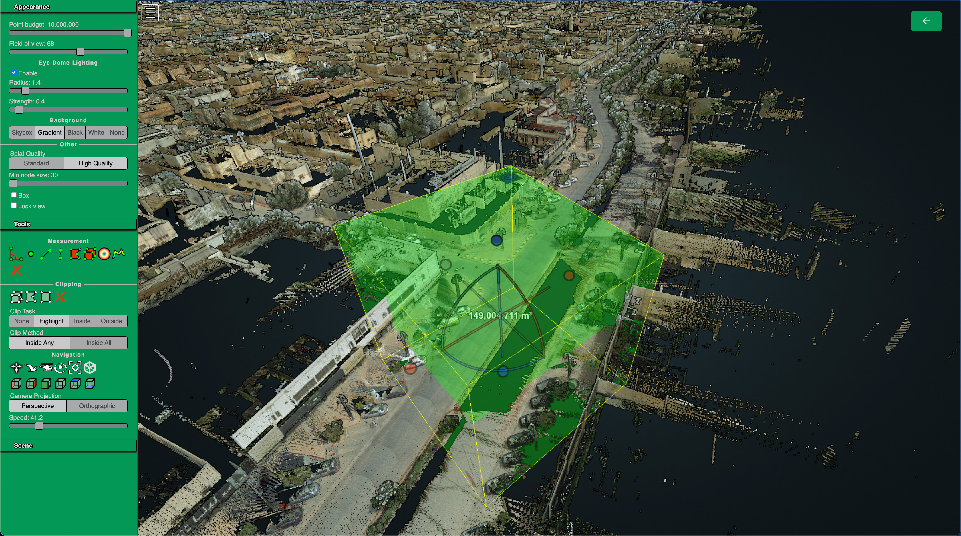
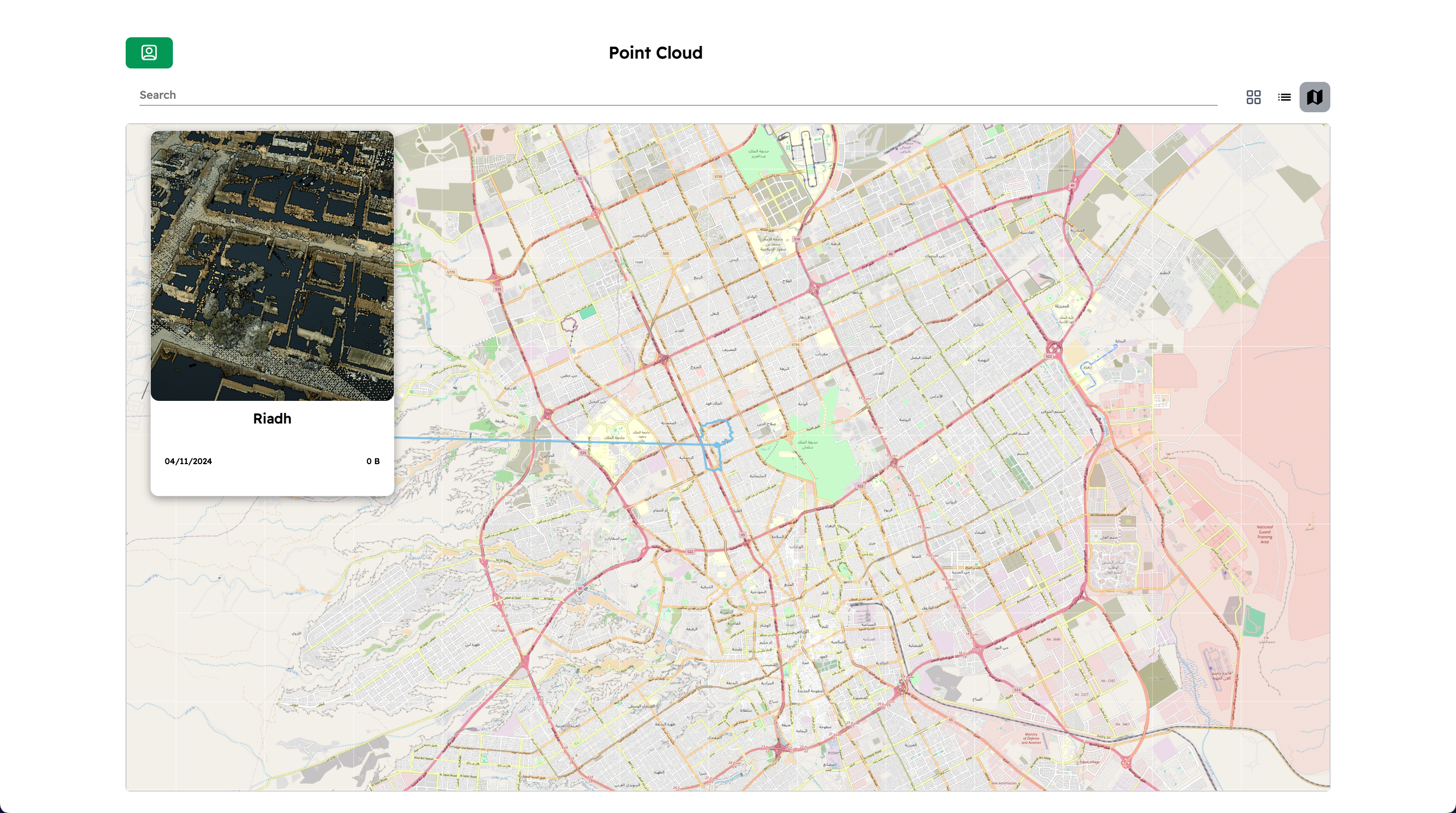
Imagery & Remote-Sensing Analysis
Leverage AI and computer vision to process satellite, aerial, and drone imagery for object detection, semantic segmentation, and change monitoring. Identify buildings, vegetation, infrastructure, or environmental shifts with pixel-level precision.
Vector & Map Intelligence
Automate map creation, vectorization, and feature extraction from raster data. GeoAI models detect and digitize roads, land parcels, and structures, generating ready-to-use GIS layers compatible with ArcGIS and QGIS workflows.
Spatial Prediction & Forecasting
Use predictive GeoAI models to forecast flood risks, crop yields, demand hotspots, or mobility trends. Integrate spatial-temporal data and deep learning to anticipate change and optimize decision-making before it happens.
Conversational & Agentic GeoAI
Deploy AI-powered map assistants and natural language interfaces (NLP) for geospatial data exploration. Ask complex spatial questions in plain English and get instant, visualized answers directly on interactive maps.
Edge & On-Prem GeoAI
Run geospatial AI models locally or at the edge for high-security or low-connectivity environments. Designed for government, defense, and enterprise sectors, Edge GeoAI ensures fast inference, full data control, and compliance with privacy standards.
Industries
Agriculture
Geospatial Sector
Transport and Supply Chain

Retail & E-Commerce

Real Estate
Energy industry
How GeoAI Services Work
Our GeoAI workflow transforms raw spatial data into actionable, high-value insights through a streamlined, four-stage process. Each stage — from data collection to visualization and integration — is built for scalability, precision, and automation.
1. Data Ingestion
2. Model Inference
3. Visualization & Insights
4. API Integration & Automation
Meet the Team

Ievgen Lavrishko

Khrystyna Bochko

Alevtyna Kostianchuk

Andriiana Pavlyshyn

Roman Nahaiovskyi

Maria Kizim
