AI/ML Solutions for Businesses | Hire GIS-Point team for intelligent automation and data-driven decision-making
GIS-Point

AI/ML Solutions for Businesses

Transform geospatial data into strategic insights with artificial intelligence and machine learning.
Contact us

Choose GIS-Point – Applied AI/ML for Real-World Geospatial Impact

In an era where geospatial data volumes are rapidly increasing, efficient processing and analysis have become critically important. Our AI/ML solutions assist in automating the processing of GIS and GEO data, detecting anomalies, forecasting changes, and optimizing infrastructure management.

390
+
Projects in UK, Europe and America
6
+
years
Of experience in geospatial AI/ML development and consulting
170
+
satisfied customers
350
K+
km²
Of terrain and spatial data processed using AI-based solutions

What Is AI/ML Solutions?

At GIS-Point, we build custom AI/ML solutions that bring intelligence to geospatial data. From anomaly detection to automated classification of point clouds and satellite imagery, our models streamline data-heavy processes and uncover actionable insights. We offer consulting, development, and implementation support — helping organizations understand where AI adds value and how to deploy it effectively.

Whether it’s predicting flood-prone areas, optimizing logistics routes, or enhancing telecom coverage, our AI-powered tools are tailored to real business needs. With scalable architecture, measurable KPIs, and deep expertise in GIS and data science, we help industries turn geospatial data into a strategic asset.

Our AI/ML Services

AI/ML Consulting

We assist companies in identifying how artificial intelligence and machine learning can deliver maximum benefits in their respective industries:

  • Analyzing current processes and data to identify opportunities for automation and optimization.
  • Determining potential points for AI/ML implementation to enhance efficiency.
  • Developing a strategic plan for implementing AI/ML solutions, considering industry specifics.

AI/ML Solution Development

We create customized solutions for processing geospatial data, including:

  • Point Cloud Classification: Automatic recognition and classification of objects based on LiDAR data.
  • Object Detection in Images: Identification of infrastructure elements, buildings, vegetation, etc.
  • Landscape Change Prediction: Modeling erosion, flooding, and changes in vegetation cover.
  • Route and Logistics Optimization: Analyzing traffic, weather conditions, and road status to improve delivery routes.

Ready to Transform Your Geospatial Data into Strategic Insigts?

Contact us to learn how AI/ML solutions from GIS-Point can enhance your business efficiency, optimize processes, and unlock new growth opportunties.

Get in touch

Industries Solutions

Agriculture

AI analyzes satellite images to monitor crops, predict yields, and optimize resource usage.

Telecommunications

Machine learning enhances network coverage, optimizes base station placement, and forecasts network load.

Energy

AI aids in infrastructure monitoring, demand forecasting, and optimizing the placement of renewable energy sources.

Construction

Applying AI to analyze construction site images, identify risks, and optimize project management.

Delivery and Logistics

AI optimizes delivery routes, predicts delays, and improves supply chain management.

Real Estate

Geospatial analytics with AI enables property valuation, market trend analysis, and identification of investment opportunities.

Geodesy

AI automates LiDAR data processing, enhances measurement accuracy, and simplifies the creation of digital terrain models.

Working on the Project:
A Step-by-Step Journey to Success

01

PREPARATION

You give us a pilot project – set us a
task, provide samples, templates,
instructions.
02

PILOT PROJECT

We carry out this pilot project
for FREE, according to all your
instructions.
03

AGREEMENT

You evaluate our work, we agree on
the cost of further work
04

LET’S STARTED!

We sign a cooperation agreement and
NDA, after which our team gets to
work.

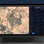
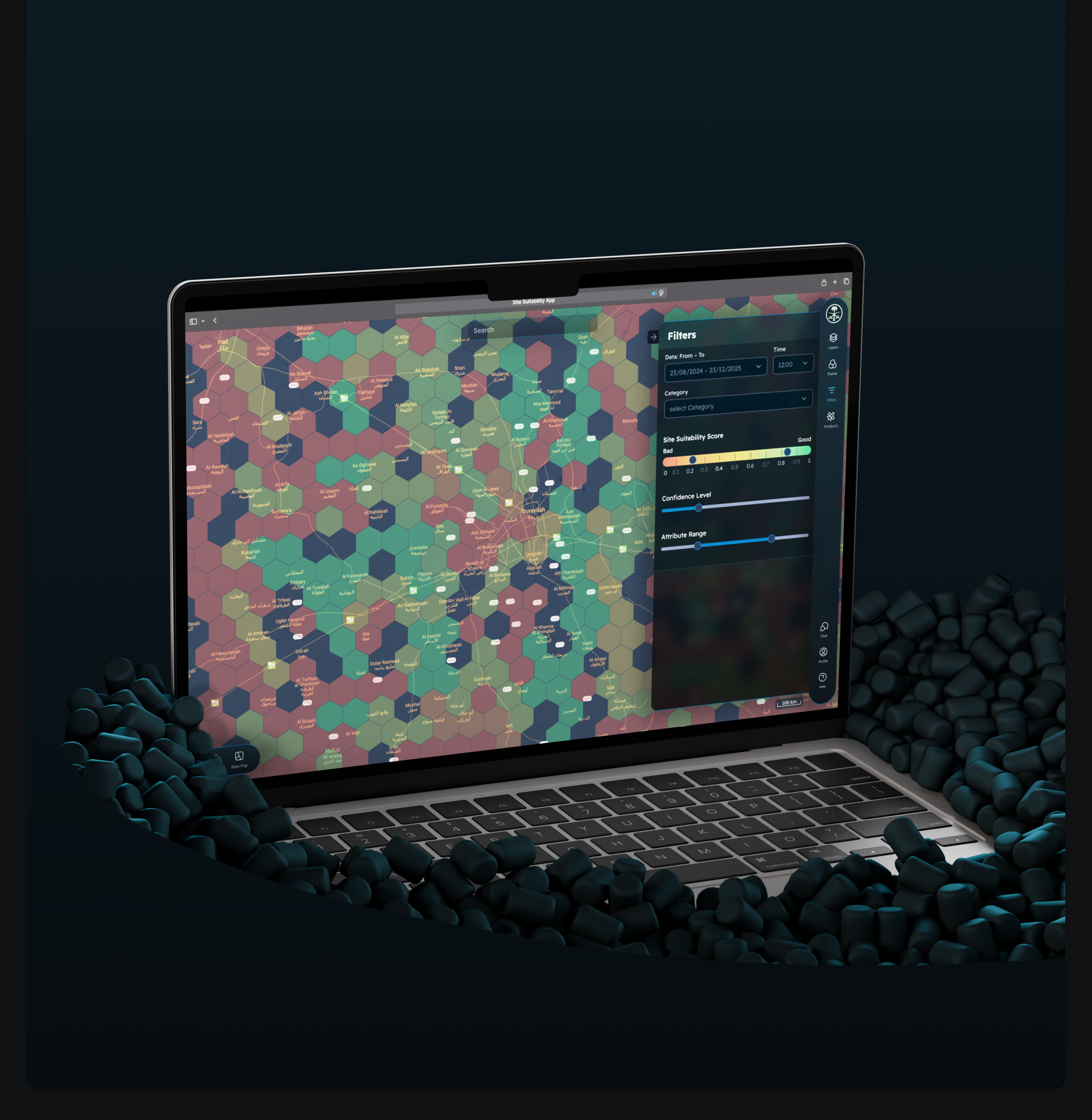
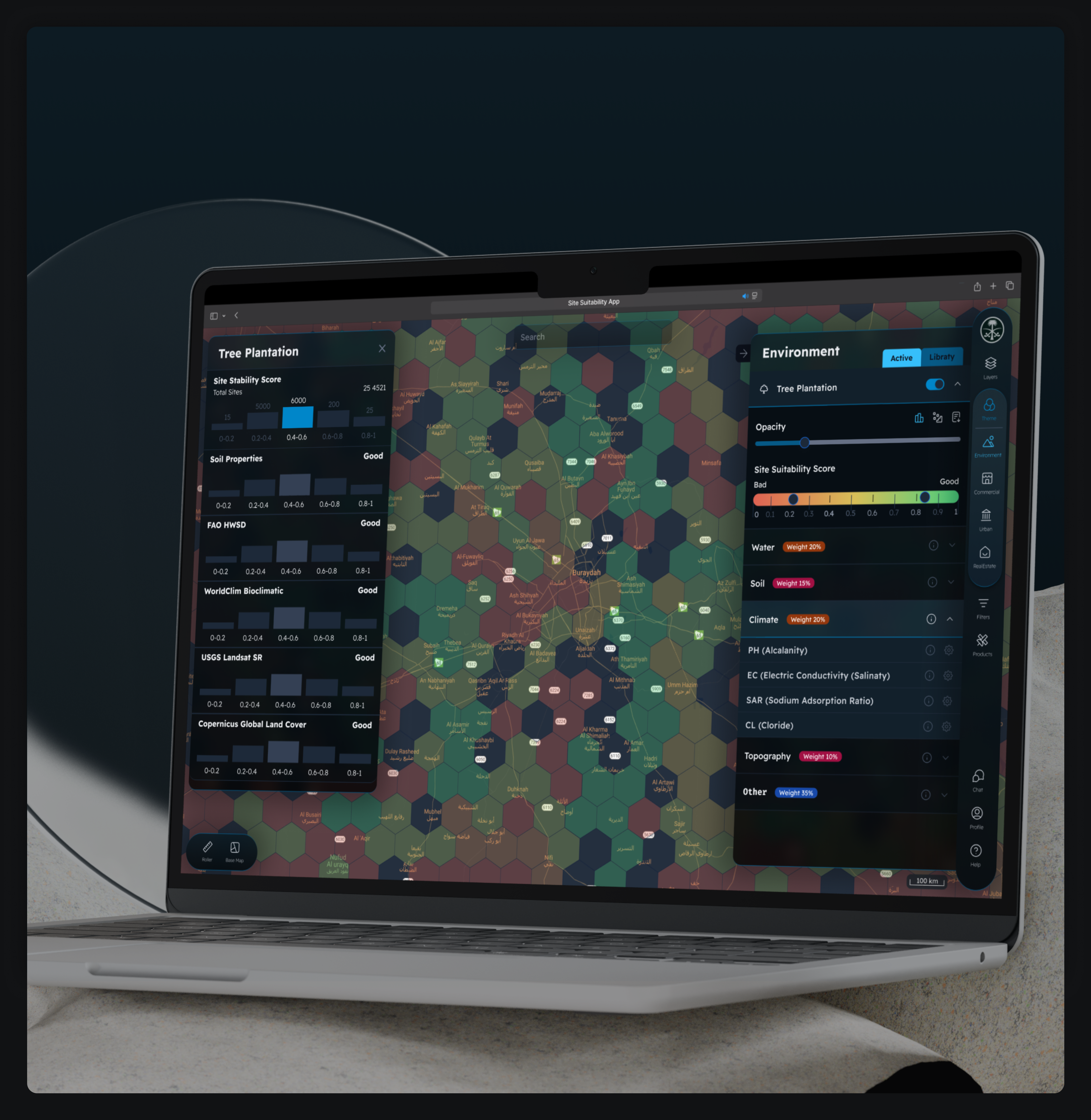
Discover Our Impactful AI/ML Projects for Geospatial Innovation

LiDAR

GIS

Development

  • Classification mobile Lidar data, 3D mapping

    This map encompasses road networks and their immediate surroundings, extending 15 meters from the road centerlines. It features comprehensive attribute information for each object, including object types, surface materials, and height above ground level.
  • Comprehensive Urban Infrastructure 2D Mapping and Attribute Database Development

    Comprehensive Urban Infrastructure 2D Mapping and Attribute Database Development
  • Classification of LiDAR point clouds for the city of Oslo

    Location:

    Norway

    Within the scope of this task, data from a portion of Oslo city was processed, specifically LAS/LAZ files and vector data for buildings, utility poles, and power transmission lines (with a focus on this vector area).
  • Topological Verification and Correction of Seafloor Maps

    Topological Verification and Correction of Seafloor Maps
  • Geospatial Analysis and Image Processing

    Location:

    Poland

    Editing the automatically generated database of motorways, bridges and roads.
  • Precision 2D Vector Map Creating at 1500 Scale

    Location:

    Latvia

    Precision 2D Vector Map Creating at 1500 Scale
  • Development of a Satellite Images Sales Platform 

    A portal for the sale of satellite images
  • Development of an Interactive Street Panorama and GIS Layer Management Platform

    Development of an Interactive Street Panorama and GIS Layer Management Platform
  • Software development for a weather forecast program

    Software development for a weather forecast program
  • Development of a Precision Agriculture Site Monitoring Platform

    Development of a Precision Agriculture Site Monitoring Platform
  • Development of a Web-Based 3D Point Cloud Visualization Platform

    Development of a Web-Based 3D Point Cloud Visualization Platform
  • Web Platform for Digital Soil Mapping and Analysis

    Development Web Platform for Digital Soil Mapping and Analysis

Want to automate, optimize, and predict with your geospatial data?

We are ready to tailor our solutions to your business’s specific needs and ensure the effective implementation of AI/ML technologies to achieve your goals.

Get in touch
Our goal is to elevate our services by providing clients with rapid assistance and a superior level of service. The higher the quality of our services, the more time and money our clients save. And we excel at this!

Ievgen Lavrishko

Customers have no doubt about our expertise

Bell Ingram Design are delighted with the service provided by GISPoint in support of our work for our clients in rural Perthshire. The point cloud data from our local survey team was passed to your team in Ukraine and they turned it round into a useable 3D Revit model of the Grade B Listed Building more quickly than we could have hoped for.

At all times we were kept up to date with progress images, and the final product has proved to be a very robust basis for our design proposals. We will definitely be working with GISPoint again in the future.

We would like to extend our sincere thanks for the exceptional support and collaboration that we received during our recent project. Your team’s expertise, professionalism, and commitment to quality were instrumental in the success of our project.

We were particularly impressed with your team’s ability to quickly understand our needs and provide customized solutions that exceeded our expectations. Your communication and responsiveness throughout the project were also greatly appreciated.

We look forward to the opportunity to work with GISpoint Team ag…

Stanislav Mudrak

MDP GEO Testimonial

From the end of 2022, the GIS POINT company is one of our cooperating partners within the project focused on mobile mapping.

GIS Point participates in the evaluation of 3D data from mobile mapping – laser point cloud and panoramic photos. After they have been trained at the very beginning of the cooperation, the results are submitted on their part in the required quality and time.

The representatives of GIS Point are able to respond operatively and solve any requirements that arise in a very short time. If something needs to be resolved, they have no …

Jiří Habrovec

GEODROM Testimonial

We wanted to take a moment to express our appreciation for the productive and effective collaboration that we experienced during our recent project. The expertise and dedication of your team were invaluable in helping us achieve our goals, and we are grateful for your hard work and commitment.

We were particularly impressed with your team’s attention to detail and ability to consistently deliver high-quality results within our tight timelines. Your flexibility and willingness to adapt to changing project requirements were also greatly appreciated.

Tha…

Michal Šafařík

GB-geodezie Testimonial

We started to consider cooperation with GISpoint at time of full workload. We were looking for digital spatial data processor capable to work with the latest software tools.
Due to time pressure and lack of people on the job market we contacted based on recommendation the company GISpoint from Ukraine.
The start of the cooperation with GISpoint was scheduled for April 2023. The initial negotiations went smoothly. Ievgen Lavrishko communicated helpfully on behalf of GISpoint.
The cooperation concerned a large contract with time pressure for complet…

Stanislav Madron

Review GMtech

During our cooperation with the LLC “Mirnichy” at the project: “3D Models of buildings” specialists of your enterprise have shown themselves as professionals who perform their work qualitatively and conscientiously.

Why highly appreciate cooperation with LLC “Mirnichy” because it has been proven itself as a reliable and qualified partner. All works have been done on time and with a high level. LLC “Mirnichy” has been performed the work stipulated by the contract.

David Chodarad

Our team ofprofessionals

Ievgen Lavrishko
CEO & Owner
Khrystyna Bochko
HR Generalist
Alevtyna Kostianchuk
Senior Project Manager
Andriiana Pavlyshyn
Head of Business Development
Roman Nahaiovskyi
Project Manager
Maria Kizim
Lead Generation Specialist
Ivanna Soltys
Tender Manager

Why Choose GIS-Point?

  • Deep Expertise in GIS, AI/ML, and Geospatial Data Processing

    We combine profound knowledge in geospatial technologies with advanced AI/ML solutions, enabling the creation of highly accurate terrain models, automation of Geo/GIS data processing, and forecasting infrastructure changes

  • Personalized Approach to Each Client

    We develop solutions that precisely meet your needs, considering industry specifics and business processe.

  • Full-Service Cycl

    From consulting and data analysis to the implementation and support of AI/ML solutions, we provide a comprehensive range of services for efficient geospatial data managemet.

  • Flexible Architecture and Scalabiliy

    Our solutions are built on a modular architecture, allowing easy integration into existing systems and scalability to meet growing business demads.

  • Transparency and Measurable Resuts

    We establish clear KPIs for each project, enabling the tracking of implemented solutions’ effectiveness and informed business decision-maing.

Contact us today to start your project!

    United Kingdom

    Devonshire str., 41, Ground Floor, London W1G 7AJ, UK

    Estonia

    Harju maakond, Tallinn, Kesklinna linnaosa, Kaupmehe tn 7-120, 10114, Estonia