

How Farmers Cut Crop Losses by 20% Using Satellite-Based Monitoring
by Ievhen Lavrishko, CEO Gis-Point
Why Modern Farming Can No Longer Be ‘Manual’
Agriculture today is facing some of the toughest challenges in history. Climate change is reshaping growing seasons, water resources are under pressure, and global food demand keeps rising. For farmers in arid regions like Saudi Arabia, these challenges are amplified tenfold.
Here, a single miscalculation in irrigation or late detection of crop stress can cost thousands of dollars. Every hectare counts. Every decision matters.
That’s why modern agriculture is increasingly less about working harder and more about working smarter – leveraging automation, geospatial data, and satellite technology to make informed, proactive decisions.
The first time I stood in a Saudi wheat field, I understood just how fragile the balance was. The soil, the heat, the irrigation schedule – everything had to align perfectly. Farmers weren’t lacking dedication; they were lacking visibility.
Some relied on manual inspections, walking the fields under the scorching sun. Others hired consultants to check the land every few weeks. But by the time early signs of drought or nutrient deficiency were visible to the human eye, the damage was often irreversible.
I remember thinking: We don’t need another report two weeks later. We need to know what’s happening now.
This moment set the stage for a new approach – field intelligence powered by satellite data.
Agriculture has always been about observation. But traditional methods struggle in today’s realities:
- Manual field scouting is reactive and slow.
By the time stress is visible, yield loss has already begun. - Climate volatility makes old routines unreliable.
Rainfall patterns are less predictable, and irrigation mistakes are costly. - Existing digital tools are either too complex or too detached from real needs.
Many platforms are built for government or scientific use, not for farmers making daily decisions.
The result? Farms operate blind for weeks at a time, and decisions are made reactively, often too late to prevent losses.
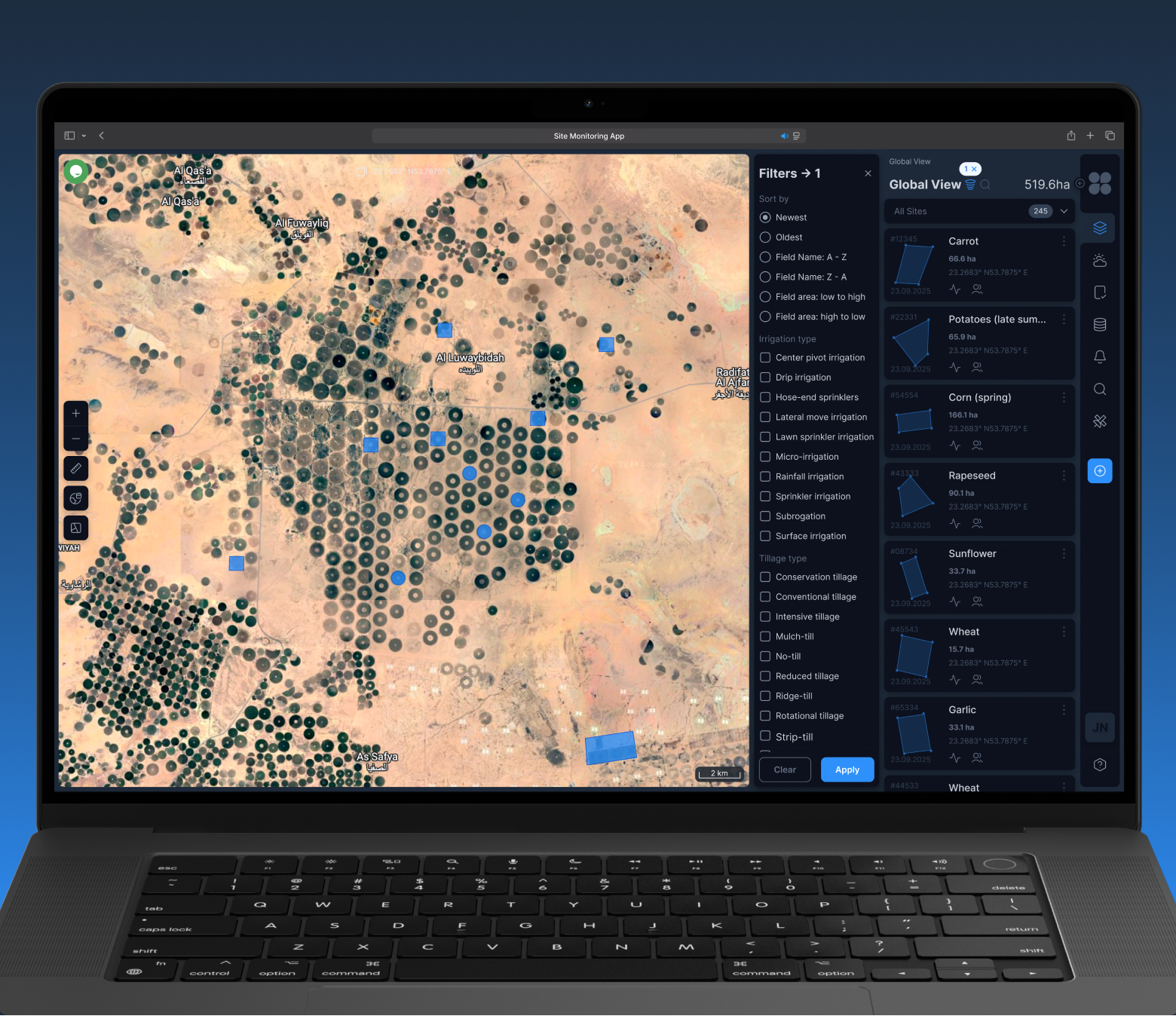
To close this information gap, our team developed a field-centric monitoring platform that turns geospatial data into actionable insights.
In just six months, we built a system that integrates:
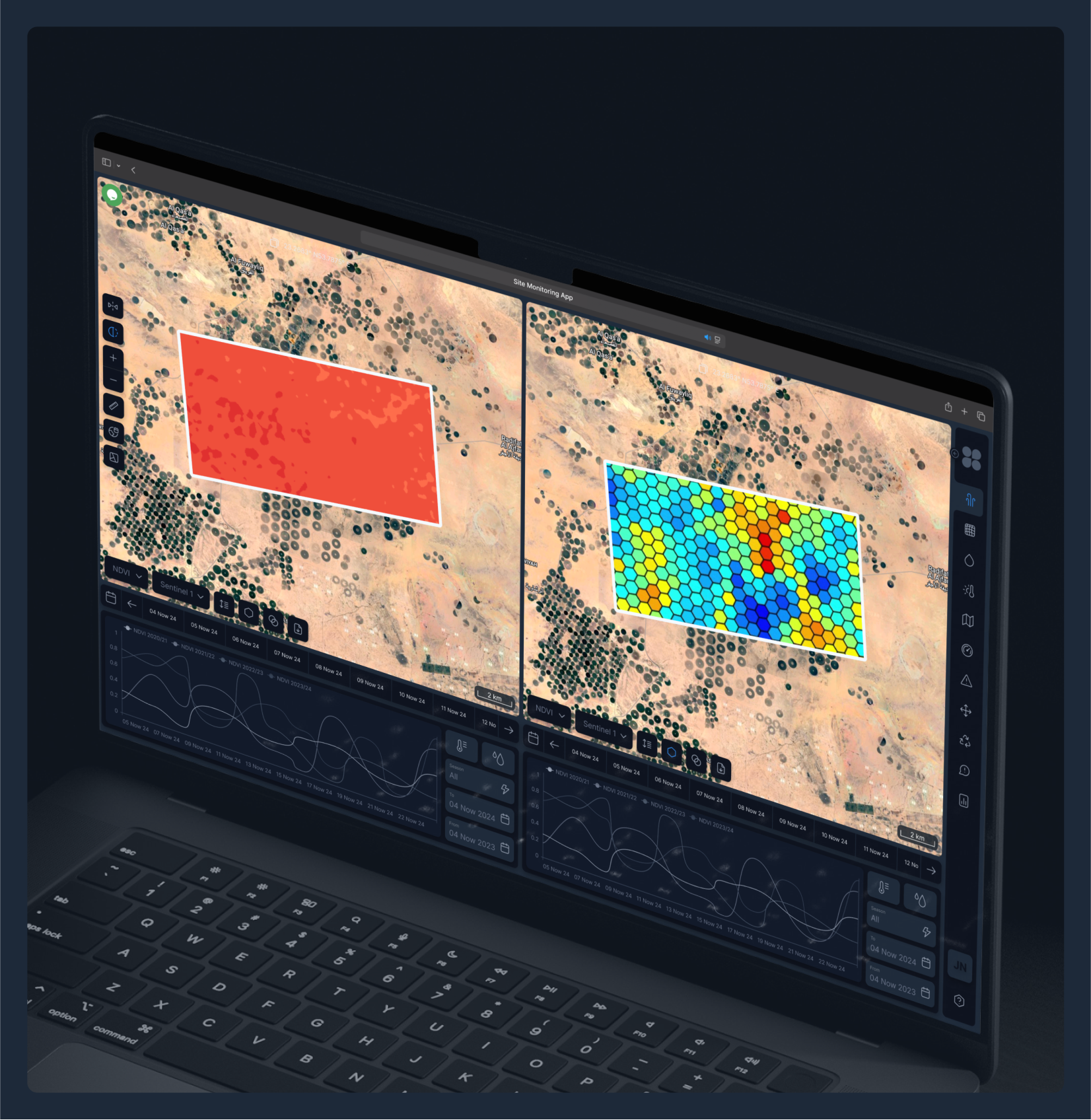
- Satellite imagery (Sentinel-2) and NDVI analytics for real-time vegetation health tracking
- Soil moisture and rainfall patterns for better water management
- Automated alerts when fields show early signs of stress
The interface was designed to respect the farmer’s time:
- Web-based, no installation needed
- Clear visual zones instead of complex dashboards
- Focused on action, not on overwhelming charts and layers
For many farms, this was the first time they could see their land as a living, dynamic system, without the need for GIS expertise.
When a mid-sized Saudi agri-business deployed the platform across multiple regions, the changes were immediate:
- Irrigation planning improved – water was allocated to fields that needed it most
- Stress zones were detected earlier – giving agronomists time to act
- Field visits became targeted – fewer hours in the sun, more impact per inspection
By the end of the season, the farm reported:
- ~20% reduction in crop losses
- Better predictability of harvest volumes
- Higher confidence in decision-making
Perhaps the most important change was cultural: decisions shifted from reactive to proactive. Farmers stopped guessing and started anticipating.
This case reflects a larger shift in global agriculture:
- 🌎 Food security under climate stress – precision monitoring helps stabilize yields
- 💧 Smarter water use – essential in arid regions like KSA
- ⚡ Operational efficiency – fewer wasted hours and resources
- 📊 Data-driven confidence – farmers can plan logistics, procurement, and harvests based on evidence, not assumptions
By integrating automation and geospatial intelligence, farms don’t just save crops; they build resilience against the unpredictable.
Adoption succeeded because we removed friction:
- Farmers could start with a demo of their own fields
- The platform scaled from small plots to 10,000+ hectares
- Everything ran in the cloud, ensuring speed and reliability
- Teams could collaborate – from the field to the office – without learning complex GIS tools
The technology didn’t replace people; it amplified their expertise.
I’m Ievgen Lavrishko, CEO of GIS-Point, and I believe that technology is the only true lever that can change the world for the better.
In agriculture, in urban planning, in logistics – data and automation are the tools that transform industries, making them more sustainable and resilient. This belief drives everything we do at GIS-Point.
We help companies turn geospatial data into real decisions – whether it’s saving crops in Saudi Arabia or digitizing infrastructure in Europe. Our mission is to bring clarity where uncertainty has been the norm.
Agriculture in the Middle East is entering a new era where seeing earlier means saving more.
Satellite-based field monitoring doesn’t just reduce crop losses – it gives farmers back control in an environment where every decision is high-stakes.
The Saudi case proves that with the right mix of data, automation, and practical design, even the harshest landscapes can yield not just crops, but confidence.
Ready to see what’s happening in your fields—before it becomes a problem?
Let’s explore how satellite-based monitoring could work for your specific region and crops.
I offer a free 30-minute consultation to walk you through a demo using your own fields. No pressure, no obligations—just a clear look at how data can transform your farm’s future.