
Project Details

Client: A geodetic and engineering company specializing in surveying, property management, and geospatial solutions.
Sector: LIDAR Data Processing
Sub Sector:
- 3D Modeling
- Infrastructure
Services:
- LiDAR Data Analysis
- 3D Model Creation
- Infrastructure Analysis
Solution:
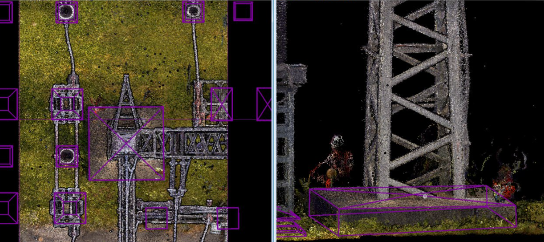
- Creation of digital 3D models for concrete poles based on laser scanning
- Evaluation of different types of concrete poles (5 types identified)
- Model creation for the first concrete pole, free from obstructions like grass
- Copying and adjusting models for other poles with modifications in height and orientation
- Correction of models to eliminate any inaccuracies
Location: Czech Republic

Technology and Software:
- Bentley MicroStation: Used for 3D modeling
- Terra solid: Utilized for processing LIDAR data and creating precise models
People:
The project was carried out by a team of experts at GisPoint, specializing in LIDAR data processing and 3D modeling. Their extensive experience ensured precise and efficient creation of models while maintaining a high level of accuracy.
Process & Challenges
Process:
Pole Evaluation: Initial assessment identified five recurring types of concrete poles.
Model Creation: A 3D model of the first pole was created, using a reference pole without obstructions.
Copy and Adjustment: The base model was copied and modified for the remaining poles, adjusting height and orientation to match specific measurements.
Final Adjustments: All models were reviewed and corrected for any inaccuracies.
Challenges:
Ensuring the accurate creation of concrete pole models despite obstructions such as grass.
Adjusting the orientation and height of each pole to reflect real-world dimensions.
Managing minor deviations in pole shapes and dimensions efficiently.
Result


Our Team

Ievgen Lavrishko

Khrystyna Bochko

Alevtyna Kostianchuk

Andriiana Pavlyshyn

Roman Nahaiovskyi

Maria Kizim

Ivanna Soltys
Navigating Our Impressive GIS Portfolio
-
Location:
Czech Republic
The input data is a cloud of Lidar points obtained using mobile Lidar scanning, as well as orthophoto maps, 360 panoramic photos. -
Location:
Czech Republic
To create a digital 3D map from mobile lidar scanning data and panoramic imagery.


-
Creation and updating of topographics data and underground communications databases on a scale of 1:500.


-
Utilizing data from mobile LiDAR scanning, panoramic imagery, and digital elevation maps, our project focuses on the development of an intricate 3D-map.


-
This project focuses on generating a Digital Terrain Model (DTM) using LiDAR data.


Working on the Project:
A Step-by-Step Journey to Success
PREPARATION
task, provide samples, templates,
instructions.
PILOT PROJECT
for FREE, according to all your
instructions.
AGREEMENT
the cost of further work.
LET’S STARTED!
NDA, after which our team gets to
work.
Have a similar project?
Contact us, we’ll help with its implementation.
United Kingdom
Devonshire str., 41, Ground Floor, London W1G 7AJ, UK
Estonia
Harju maakond, Tallinn, Kesklinna linnaosa, Kaupmehe tn 7-120, 10114, Estonia
Ukraine
Ukraine, Lviv, Sadova street, 2a/1
+380672088520 Ievgen Lavrishko
info@gis-point.com


